I first set foot in Florida back in 1984, on spring break from my sophomore year of high school. I was accompanying my dad on a plane trip that was to take us from our home in L.A.’s San Fernando Valley, located in a basin between the San Gabriel and the Santa Monica mountains, all the way around the perimeter of the lower 48 states: from L.A. south along the Pacific Ocean all the way to the Mexico border, hang a left and go straight along that imaginary line until we hit the Rio Grande, then follow the natural geography of the unsubmerged portion of the continental shelf all the way to Maine, I guess. (As it turns out, I never found out how easy that would have been; we were delayed by thunderstorms in Florida and snowstorms in Connecticut, and we had to hustle back across the country, putting in some truly massive marathon daylight flights.)
The itinerary was an exciting idea, and like many ideas, it’s the conception, rather than the execution, that holds the true thrill. There’s just no way to feel in one’s viscera for 8 straight very long days the intellectual thrill of flying all the way around the country in the backseat of a VariEze. But the scenery was interesting, and once we left the mountains behind, it was all pretty much new to me. I wish that digital cameras had existed back then; I’d love to have some snapshots of this trip now, if only to serve as a photo gallery for this blog…
At the beginning we flew fairly high, both to increase our fuel economy and our comfort. The ground was a long way down, but if you know anything about the skies in the West, you know that the sky was higher still. The air out there is dry, desert dry. Clouds simply cannot exist close to that much aridity; it’s only high, high up that what little moisture there is is able to coalesce into clouds.
The view from that high up over the West, where I’d grown up, was familiar, and while I hadn’t actually been in all the places we were flying over (not much call to go straddle the line between Mexico and the U.S. then, and not much call now, unless you’re a newfangled minuteman, in which case I advise you to get a grip), I could easily imagine having been there, since I’d been in many places that looked almost exactly the same.
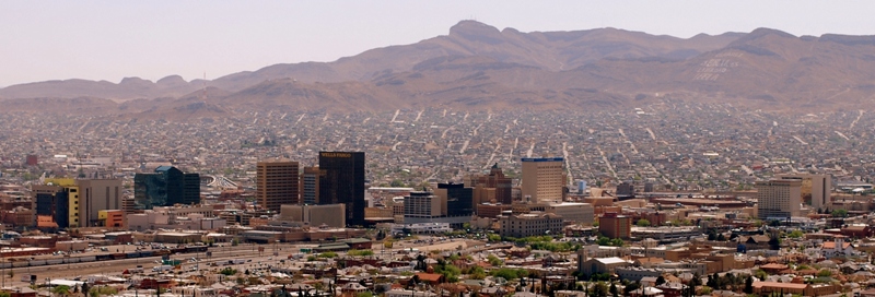
El Paso was our first stop; the Franklin Mountains, which come to an abrupt halt right in the middle of the city, made quite an impression on me (image from Wikipedia):

If memory serves me, the airport was on one side of the mountains, and our overnight accommodations were on the other. But it was only a short drive, because we didn’t have to drive over the mountains, just around them.
The stop after El Paso was Houston–that’s right, Texas is so big that even in our little airplane, it took all day to circumnavigate. One day to get from California through Arizona and New Mexico and just barely squeak into Texas, and then an entire days’ flying and still in Texas. Whooee!
On the way to Houston we followed the curves of the Rio Grande from El Paso, over Laredo, all the way to Brownsville (what I wouldn’t give to be able to do this part of the trip again, on the ground! Birding the Big Bend!), which was conveniently located both close to our flight path and just in time for lunch. Brownsville is about as far south as you can get on the mainland of the United States (Key West, which is the southernmost point on the unsubmerged land-connected United States portion of the continental shelf, is of course, not on the mainland.), and as we descended from our high flight, we rapidly noticed that we had left the dry air of the West behind somewhere: it was getting hotter and hotter, and more and humid, as we got closer to the ground. Welcome to the East!
On we pressed to Houston, and then, on the third day, we crossed through Louisiana, Mississippi, Alabama, and on into Florida. We had lunch at a little town in Mississippi (Gulfport, if I remember right, but I might not: I was 14 at the time, and am rapidly approaching the palindrome of that age). From there, it was supposed to be a pretty easy flight to our next stop: Somewhere in Florida.
Around here, I lose the chronology a little (Florida will do that to you). The main thing I remember about the state in 1984 was how low the ceiling was. Practically as soon as we hit the Florida border, we had to start descending, because the cloud deck was so low. There’s simply so much moisture in this state, even in April, that the clouds can form really, really close to the ground.
I read somewhere (can’t remember where) that, although the highest point of land in Florida is only 385 feet, the state does have mountains: our towering cumulonimbus thunderstorms. Seeing them through the lens of someone like Clyde Butcher encourages this idea, and I have to say that it has some merit, but I do miss the real mountains. And I have to say that my first impression of Florida’s clouds wasn’t anything like an amazing tower 50,000 feet high. It was just a bunch of little gray clouds with rain coming down from most of them. Not hard, driving rain, but enough to interfere with our enjoyment of the day.
I had never seen so many clouds so low to the ground, without it looking like, well, fog. This wasn’t fog, though; these were individual clouds, but so many, and so close together, and above all so low, that we had to do some pretty serious fudging of the rules of visual flight to enable us to get anywhere at all. As it was, we had to make an unplanned overnight somewhere on the peninsula (Pop would remember the spot, I hope).
The next day we continued on around the tip of the peninsula, spying the condos and hotels of Miami Beach from the air, and continuing our route up to Cocoa Beach, Florida. Here I got another dose of difference: while the Atlantic Ocean in Florida resembles the Pacific Ocean in California in several respects (it’s large, it’s salt water, it has waves), there is a palpable difference between the two. The water in Florida is warm. Coming from the cold water of the beaches swept by the California current, where the beach is only marginally fun without a wetsuit for a few months of the year (July and August, maybe September if you could get to the beach instead of school), this was a shock, although a pleasant one.
So, as I freeze here in the grips of the coldest spell I can remember (last year, right around this same time, we had some pretty cold weather), it’s nice to think back to the time when I first met this unruly appendage of America we call Florida. No clouds in sight today.

What a great article you’ve written! It does bring back the memories. We certainly didn’t know then how keeping a logbook could be helpful 26 years later. On April 14 we took 5.3 hours to fly from Houston to Perry, Fl, then the next day it was 4.7 hours around FL to Merritt Island at Cape Canaveral. The following day it took only 4.5 hours to go all the way to Atlantic City, which short time I would never have believed had I not recorded it. But my flight note does say we had a strong tail wind, so we must have gone faster than the 175 MPH I plan for.
I can only remember actually hitting a bird once in flight in all these years. By the time I landed I had computed in my head that the airplane moves forward something like 6 feet for every 1/2 turn of the propeller, so there was a bigger gap there for him to fit through than might be intuitively obvious.
Pop
Ah, Perry. That was the place! Pretty far north in the state. Not even sure whether it considers itself part of the peninsula or part of the panhandle.